HORIZON INTERNATIONAL SOLUTIONS SITE
Working to Find and advance solutions to environment, health, poverty, and development problems
Ocean: An Illustrated Atlas, by Sylvia A. Earle and Linda K. Glover just released (2009) by National Geographic offers state of the art maps of the ocean’s sea floors including the areas of the newly designated National Marine Monuments.
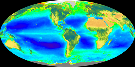 |
| NOAA Clorophyll Globe Chlorophyll in the ocean: Black areas in the Atlantic and Pacific Oceans are the least productive. Dark blue areas in this figure of the global distribution of chlorophyll are the areas with the least surface chlorophyll. The least biologically productive areas of the oceans are expanding much faster than predicted, according to a study by researchers at NOAA and the University of Hawaii released in March 2008. This change in ocean biology, linked to the warming of sea surface waters, may negatively affect the populations of many fish species trying to survive in these desert-like environments. The evidence of this expansion comes from data collected by a sensor aboard NASA’s orbiting SeaStar spacecraft. The Sea-viewing Wide Field-of-view Sensor, called SeaWiFS, is a unique tool that maps ocean biological productivity around the globe. This visual sensor reads reflective color to measure the density of chlorophyll in phytoplankton, the microscopic plants that are the base of the marine food web. The research showed that the areas of low productivity in the Pacific Ocean are expanding from the center toward Hawaii. In the Atlantic Ocean, the least productive areas of the subtropical gyre are expanding at an even more rapid rate eastward across the Caribbean toward Africa. The low-productivity zones, likened to deserts, now cover an estimated 51 million square kilometers in the two oceans. The least productive area of the Indian Ocean shows the same trend, but there has been too much variability for it to be statistically significant. Text: and image NOAA |
Ocean: An Illustrated Atlas, by Sylvia A. Earle and Linda K. Glover just released (2009) by National Geographic offers state of the art maps of the ocean’s sea floors including the areas of the newly designated National Marine Monuments.
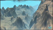 |
| Marianasicion Trench Animation Mariana Trench Dive Animation These animations were produced by Dr. Peter Sloss of NOAA's National Geophysical Data Center (NGDC), Marine Geology and Geophysics Division, from actual digital bathymetric data archived by, and available through NGDC. Photo: NOAA National Geophysical Data Center (NGDC) |
Mariana Trench Dive Animation: The Mariana Trench may be the deepest place in the world's oceans, but these videos have the vertical dimension strongly exaggerated to further enhance the visual effect. The maximum depth of the trench is a little greater than 11 kilometers, but its width is over 50 kilometers. The color scheme chosen is arbitrary but represents a typical color for the ocean bottom.
In this book readers are taken into the depths of the oceans with over 100 maps including 5 especially created maps of the sea floor of the major basins with details never before seen.
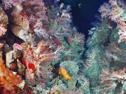 |
| Pacific Ring of Fire Expedition. Stunning image of Aquarium site. A picturesque gully with abundant life including algae (red and green), soft corals (pink with white stalks) and tropical fish abound. Image ID: expl0017, Voyage To Inner Space - Exploring the Seas With NOAA Collect Mariana Arc region, Western Pacific Ocean Photo: Pacific Ring of Fire 2004 Expedition. NOAA Office of Ocean Exploration; Dr. Bob Embley, NOAA PMEL, Chief Scientist |
In her interview with the New York Times for an article about the Atlas, Mapping the Sea and Its Mysteries that appeared in the Science section on Tuesday, January 13, 2009, Dr. Earle mused, “So many things have been discovered…. “But then you turn around and — there’s another breakthrough. We’ll probably have to update the atlas in five years.” According to the Times, she “had a hand in President Bush’s designation …of vast parts of the American-controlled Pacific Ocean as marine monuments.”
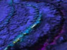 |
| Mariana Arc Sea Floor Video NOAA: Take a trip to the seafloor of the Mariana Arc! Video |
National Oceanic and Atmospheric Administration (NOAA): Take a trip to the seafloor of the Mariana Arc! The fly-over begins by looking at the entire Marianas trench, Mariana arc and backarc. The darker purple/blue background is satellite data grid (3500 meter resolution) representing islands and volcanoes (3500 meter grid). Then we zoom in to the area of Ahyi, Makhanas and NW Uracas volcanoes. The latter, high resolution (lighter color) data are the EM300 multibeam bathymetry (35 meter grid). Movie thanks to support from Interactive Visualization Systems.
Among the wonders Dr. Earle reported in the Atlas the New York Times cited, is “that some 90 percent of deep-sea creatures use bioluminescence in their life strategies and that the eerie glows may turn out to constitute the planet’s most common form of communication.”
The Atlas section “Valuing the Living Ocean” Dr Earle writes: “Included among the major discoveries of the latter part of the 20th century unknown or not well known or not well understood in the 1960s were some ocean basics:
"The most important discoveries, however, may have been the awareness that the ocean is not infinitely resilient and that the nature of the world-and thus its capacity to support humankind-is shaped by the state of the ocean.”
Dr. Earle’s continues by emphasizing that “Never before has there been a greater need to understand all aspects of the deep frontier and to provide a sound knowledge base for crucial decisions that will otherwise be made in ignorance. And never again will there be better opportunities to explore and protect the natural ocean systems that are crucial to the future of humankind on this planet.”
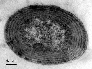 |
| Prochlorococcus, Synechococcus and Prochlorococcus, tiny organisms that account for up to two-thirds of the carbon dioxide "fixation" (the conversion of carbon dioxide into organic compounds during photosynthesis) in the oceans and are key players in marine food webs. By knowing their genetic makeup, the scientists say, researchers will better be able to understand how these organisms process carbon, leading to a better understanding of the global carbon cycle. Text: Scripps Institute of Oceanography. Photograph: The oceanic cyanobacterium Prochlorococcus observed by transmission electron microscopy (TEM) by William K. Li and Frédéric Partensky. Wikipedia Photo: Wikipedia |
Prochlorococcus, a cyanobacterium Dr. Earle cites in her Times interview, is “so small that millions can fit in a drop of water.” It has achieved fame “as perhaps the most abundant photosynthetic organism on the planet. It daily releases countless tons of oxygen into the atmosphere…so much oxygen that it is estimated to provide the oxygen in “one of every five breaths we take.”
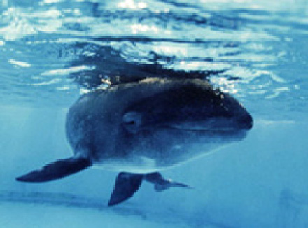 |
| NOAA Melon-headed Whale Melon-headed whales make fast, low leaps from the water as they swim.(Peponocephala electra) Melon-headed whales, like all marine mammals, are protected under the Marine Mammal Protection Act (MMPA) enacted on October 21, 1972. The MMPA prohibits, with certain exceptions, the "take" of marine mammals in U.S. waters and by U.S. citizens on the high seas, and the importation of marine mammals and marine mammal products into the U.S. Photo and Text: NOAA Photo by Keo Kistender |
Dr. Sylvia Earle writes in The Last Word of the book: “There is time, but not a lot, to use that wondrous capacity that humans have to dream, to anticipate the next decade, century, millennium, and beyond. If we so choose, we have the power to craft a world where we respect and live in peace with ourselves and with the mostly blue world that sustains us.”
The book is available from the National Geographic Society: http://www.nationalgeographic.com/.
Dr. Earle is a Special Advisor to Horizon International and participant with the Horizon Magic Porthole coral reef program, www.magicporthole.org.
Note:
The New York Times reported in its January 13, 2009, coverage of the newly released book Ocean: An Illustrated Atlas, by Sylvia A. Earle and Linda K. Glover just released (2009) by National Geographic book, Dr. Sylvia Earle “had a hand in President Bush’s designation last week of vast parts of the American-controlled Pacific Ocean as marine monuments. The new protected areas — including the ocean’s deepest spot, down nearly seven miles — are bigger than California.”
See coverage of Three Pacific Marine Protected Areas, Marine National Monuments, Established on the Horizon Solutions Site.